
When El Niño and climate change collide: What it means for a New Hampshire winter
 Copyright Valley News. May not be reprinted or used online without permission. Send requests to permission@vnews.com.")
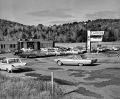
Royalton Memorial Library Director Lu Aubin shovels the sidewalk in front of the library in South Royalton, Vt., on Wednesday, Jan. 10, 2024. A large regional storm brought snow late on Tuesday that turned to rain overnight. (Valley News - James M. Patterson) Copyright Valley News. May not be reprinted or used online without permission. Send requests to permission@vnews.com. Valley News – James M. Patterson
| Published: 01-11-2024 4:30 PM |
The Granite State may have been pummeled by a good ol’ snowstorm on Sunday, but the 50-degree temperatures, rain, and flooding emergencies that followed a few days later were quick reminders that winters here are changing.
This year specifically has a unique fusion of factors: an El Niño weather pattern combining with the effects of climate change, said state climatologist and University of New Hampshire associate professor of geography Mary Stampone, causing “an enhanced warming this winter.”
El Niño and La Niña are two opposing natural climate phenomena that break from normal conditions, according to the National Oceanic and Atmospheric Administration. The two contradicting patterns can impact everything from seasonal rains in Africa, to monsoons in Asia, to New England winters.
Trade winds are weak during El Niño and strong during La Niña, ultimately influencing “hemispheric-scale seasonal weather,” Stampone said. While their impacts fluctuate and vary based on geographic location, in northern New England, El Niño is historically associated with warming and La Niña with cold.
“During El Niño, you end up having a warmer water pool off the coast of South America, and that then influences atmospheric patterns across much of the northern hemisphere,” Stampone said.
An El Niño winter is occurring for the first time in four years, and NOAA first declared its arrival in June.
As a result, the agency’s U.S. Winter Outlook predicted warmer-than-average temperatures across the northern tier of the U.S. and much of the West, noting that northern New England is among the areas with the greatest odds for such conditions.
In fact, NOAA’s blog providing updates on El Niño posted in December about a 54 percent chance this El Niño event will end up “historically strong,” potentially ranking in the top 5 on record.
Article continues after...
Yesterday's Most Read Articles
 Dartmouth administration faces fierce criticism over protest arrests
 Three vie for two Hanover Selectboard seats
 A Look Back: Upper Valley dining scene changes with the times
 Norwich author and educator sees schools as a reflection of communities
Neutral conditions are expected to return between April and June.
While an El Niño winter is nothing new, its collision with climate change can make it more pronounced, scientists say.
“Climate change can exacerbate or mitigate certain impacts related to El Niño,” said Michelle L’Heureux, climate scientist at NOAA’s Climate Prediction Center. “For example, El Niño could lead to new records for temperatures, particularly in areas that already experience above-average temperatures during El Niño.”
Stampone described it as El Niño occurring “on top” of general warming.
“Here, our winters are already warming faster than our other seasons, so there’s the climate change part,” she said. “El Niño tends to make things even warmer.”
A 2022 analysis by Climate Central – a nonprofit organization that analyzes and reports on climate science – found that winters have warmed by 3.3 degrees Fahrenheit on average across 238 U.S. locations since 1970. Parts of New England are far above the national average, including the city of Concord, which saw winters warm by 6 degrees. New England is losing temperatures below freezing, and in turn, consistent snowfall and snow cover, scientists say.
Stampone said an El Niño weather pattern also tends to make conditions a little bit wetter.
The month of December in New Hampshire, she said, saw nearly double the normal amount of rain. Heavy rains on Dec. 18 prompted road closures and evacuations in parts of the state, as a National Weather Service meteorologist called the day “a historical river flooding event for this area.”
According to Climate Central, the month of December in Concord experienced temperatures 6.8 degrees higher than normal, and the 6.93 inches of precipitation that fell was 187 percent of the normal amount.
The warming winter trends continue to have negative impacts on ski resorts, which have been forced to invest in snowmaking technology to cement their future viability.
After the December rainstorm, Waterville Valley, Wildcat Mountain, and Loon Mountain all closed in some capacity to recover.
Melody Nester, assistant director at nonprofit trade association Ski New Hampshire, said the state’s ski areas have spent “countless resources” on weatherproofing their operations, and that investments in more efficient snowmaking equipment are vital to resiliency.
“New Hampshire ski resorts have invested millions of dollars over the years in snowmaking enhancements,” she said. “These improvements allow resorts to continue to operate when Mother Nature decides she doesn’t want to cooperate. Though we can’t control the weather, we do have some control over how we enable our mountains to compensate for the lack of ideal conditions.”
 Art Notes: Canaan Meetinghouse showcase brings musicians and listeners together
 The future of fertilizer? Pee, says this Brattleboro institute
 From dirt patch to a gateway garden, a Randolph volunteer cultivates community